
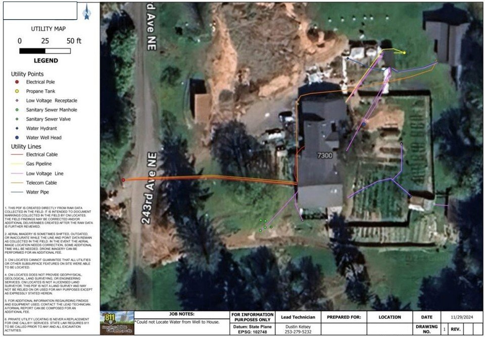
Private utility locating often starts in the field, but the real value comes from what you can do with the information afterward. GroundScout provides GIS mapping services that turn private utility locating results into organized, geo-referenced digital records you can rely on beyond the day of the scan. This service is ideal for clients who need more than temporary paint markings on the ground.
Paint fades. Flags get removed. Site conditions change. GIS mapping allows utility locating results to be captured in a permanent digital format that can be referenced during planning, design, construction, or future work. For private property, where as-built records are often missing or unreliable, GIS mapping helps preserve what was found during locating — before that information is lost.
GIS mapping is performed after or alongside field locating using:
Site measurements and positioning controls
Detected utilities are converted into geo-referenced linework and datasets that reflect actual field findings, not assumptions from outdated plans.
Private Utility Locating Services
Ground Penetrating Radar (GPR)
Utility mapping is an extension of private utility locating. After utilities are identified in the field using EM locating and GPR, that information is compiled into a mapped record that reflects observed conditions at the time of service. GIS mapping deliverables may include:
A mapped utility plan (PDF) showing located utilities
Color-coded utility systems (gas, electric, water, telecom)
A legend, scale, and site reference features
Optional interactive map access for viewing utility locations digitally
Data is structured so it can be reused, updated, and shared with designers, engineers, or project teams.
GIS utility mapping is commonly used by clients who:
Are developing or redeveloping private property
Need documentation for due diligence or planning
Want permanent records of located utilities
Manage sites with recurring excavation or maintenance
Require coordination between multiple stakeholders
If you’re already investing in private utility locating, GIS mapping helps extend the value of that work.
Pre-construction planning and layout
Design coordination and utility conflict review
Property acquisition and due diligence
Campus, facility, or site asset management
Projects with undocumented or abandoned utilities
Reduces repeat locating costs
Improves coordination across project phases
Preserves field data beyond a single visit
Supports informed decision-making
Minimizes risk from unknown subsurface conditions
GIS mapping turns one-time locating efforts into long-term infrastructure knowledge.
When used during due diligence, GIS mapping provides documented visibility into subsurface conditions before purchase, design, or construction decisions are finalized.
Utility Locating for Due Diligence
GIS utility mapping reflects field-observed conditions at the time of service. Subsurface access, utility material, and site conditions may affect results. This service supports planning and risk reduction and does not replace excavation verification.
If your project requires private utility locating with clear, documented results you can use beyond the field, GroundScout can help.