
Ordering a utility survey is one of those decisions that feels “optional” until the day it very much isn’t. If you’re planning excavation, design work, drilling, renovations, or a property transaction, a utility survey helps answer the question that drives everything else: what utilities are on site, where do they run, and what should we avoid?
At GroundScout, a utility survey is more than paint on the ground. It’s a structured process designed to reduce risk, create clarity, and—when needed—produce documentation you can use long after the field work is done.
Below is what you can expect from a typical utility survey workflow, including how to prepare, what happens on site, and what deliverables you’ll receive.
First: what a “utility survey” usually means (and what it doesn’t)
People use “utility survey” to describe a few different things. Sometimes they mean basic field markings for an upcoming dig. Sometimes they mean a mapped deliverable for design. Sometimes they mean both.
A utility survey generally involves locating visible and/or detectable underground utilities and documenting their approximate positions. It does not automatically mean engineering-grade subsurface utility engineering (SUE) unless the scope and standards explicitly say so. The practical takeaway: the quality of your results depends on the scope, methods, access, and how the deliverable is defined.
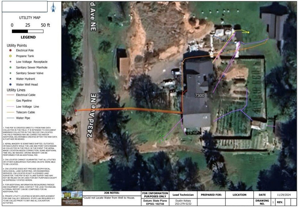
GroundScout typically supports this need through Private Utility Locating Services, and when a client wants a more permanent record, we provide Utility Mapping (PDF/GIS) as part of the deliverable.
Step 1: the intake call (where a good survey actually starts)
Expect a short kickoff where you’ll be asked what you’re doing and why you need the survey. This is where timelines, site constraints, and risk level get defined.
To speed things up, it helps to provide:
The address and a site contact
A simple drawing or description of the work area (even a screenshot is fine)
Any existing plans/as-builts, if you have them
Known utilities or past issues (previous strikes, repairs, reroutes)
Your schedule and any access restrictions (gates, tenants, security, operating hours)
This is also the moment to clarify what you actually want back: field markings only, a PDF map, a GIS-based deliverable, or a package that supports planning and documentation.
Step 2: calling 811 (and why it still matters)
Even when you’re ordering a private utility survey, 811 still matters. It’s the baseline step that helps ensure public utilities (and participating operators) are notified and marked according to local processes. Private utilities often aren’t fully covered by 811, but starting with a cleared and marked site helps reduce conflicts and improves efficiency.
If you’ve already called 811, great. If not, GroundScout can usually guide you on when to place the ticket so markings line up with the survey schedule.
Step 3: on-site locating (what the field crew is actually doing)
On site, the work depends on utility types, access points, site congestion, and what’s detectable. If utilities are conductive or have tracer wire, electromagnetic locating can often trace their alignment. If non-conductive utilities are likely—or the site is complex—GPR utility locating may be used to add confidence and capture subsurface features that don’t carry an EM signal well.
A professional survey also includes common-sense investigation: identifying likely tie-in points, reading the site visually (valves, meters, panels, vaults), and confirming suspected routes through repeatable checks. If the site is dense, technicians may take extra time to avoid “false paths” caused by interference, coupling, or signal distortion.
In other words: it’s not just walking around with a device. It’s controlled problem-solving.
Step 4: markings, notes, and “what we couldn’t confirm”
Most clients expect markings—and they should. But the more valuable part is often the context: what was confidently traced, what appears present but needs verification, and what could not be confirmed due to access or material limitations.
You should expect your provider to communicate:
Where they have high confidence
Where utilities are congested or conflicting
Where verification (potholing) is recommended before excavation
Any limitations (no access, no tracer wire, heavy interference, etc.)
That transparency is part of a good utility survey. It keeps the deliverable honest and helps you plan verification intelligently.
Step 5: deliverables (what you receive at the end)
Deliverables vary by scope, but most utility surveys end with one or more of the following:
Field markings are the immediate output—useful for crews and near-term excavation. For clients who want a lasting record, GroundScout can provide Utility Mapping (PDF/GIS) deliverables that document the located utilities in a clean format for planning, sharing, and future reference.
If you’re managing multiple sites or anticipating future work, mapping often pays for itself because it reduces repeat discovery and speeds up future planning. A good map is also easier to share across teams than “I swear it was painted over there last month.”
Common reasons utility surveys take longer than expected
Most delays come from a few predictable issues: restricted access (locked areas, tenants, security), limited connection points, heavy utility congestion, incomplete records, or utilities that are non-conductive without tracer wire. Weather and active site operations can also affect field efficiency.
None of this means the survey can’t be done—it just means timelines should reflect reality. The more you can share up front, the smoother it usually goes.
How to get the most value from your utility survey
If you want the best outcome, define the goal clearly. Are you trying to safely dig next week? Are you trying to support design? Are you trying to document the site for future projects?
When the goal is clear, the right combination of Private Utility Locating Services, GPR utility locating, and Utility Mapping (PDF/GIS) becomes obvious—and you’re less likely to pay twice for the same discovery.
Bottom line
When you order a utility survey, you should expect a short intake to define scope, a site visit that blends technology with field validation, clear communication about confidence and limitations, and deliverables that match the purpose of the work. If your project involves excavation, renovations, or long-term site planning, a well-executed utility survey reduces risk now and makes the next project easier too.